Journal of Urban Design and Mental Health; 2019:6;9
|
CITY CASE STUDY
|
From the City of Djinns to the City of Sins: how Delhi has facilitated mental wellbeing through urban design
Kriti Agarwal
Jindal School of Art & Architecture, India
Jindal School of Art & Architecture, India
Abstract
Delhi is one of the most complex cities in the world, with its various layers and sub-cities, cultures, governance etc. Delhi, has in the last decade become infamous as being the 'rape capital of India' and 'the most polluted city in the world'. Delhi’s air is polluted not just with particulate matter but with lust for power which gets manifested in its built environment in many ways. The city sees high rates of crime. Fear has come to dominate one's life and one sees it being sold in various forms - nose masks, pepper spray, CCTV’s, air purifiers, safety apps etc.
This is all on account of the way Delhi has urbanised and expanded both pre and post independence. The sheer scale and proportion of the city is forcing individuals to yield to anonymity, indifference, and narrow self interest. These individuals with different socio-economic backgrounds have different internal environments i.e. varying Mindsets. However, as a Senior Urban Designer states that the common denominator of the Human Mind is its connection with Nature, and Urban Design is needed in maintaining this continuum between Mind and Nature and as an extension: the City.
This paper discusses if and how the city of Delhi applies the principles of urban design for good mental health and well-being of its inhabitants. It has been analysed that the city has fallen into various traps that have affected the well-being of the people. Simply put, the city has failed.
It is important to clarify in the beginning that Delhi is an extremely complicated city. It is a conglomerate of various mini-cities and to do justice to it in a Paper like this is next to impossible. This study is a start towards further research into various aspects related to urban design and mental health.
Introduction
Delhi, also known as the National Capital Territory of Delhi (NCTD), is the political capital of India and a city-state-Union Territory. It is located in northern India plains with the River Yamuna towards the east and the Delhi ridge originating from the Aravalli Range towards south and west. The city experiences extremely hot summers and harsh winters with spring in between and heavy rains during the annual Monsoon. It is spread over 1,484 square kilometre having a population of nearly 17 million people as per India’s Census 2011. The United Nations World Cities Report 2016 says that a further ten million people are expected to move to Delhi by 2030.
The Centre for Urban Design and Mental Health has developed the ‘Mind the GAPS’ framework for the use of architects, planners and managers to ensure sound mental health and well-being. The GAPS framework looks at green spaces and access to nature, active places, pro-social places to encourage positive social interaction, and safety in the city; and within these sectors focusing on the aspects of sleep, transportation and connection, economic stress and affordability, and air pollution. The planning and development of Delhi is analysed using this framework while highlighting specific mental health issues being faced and projects undertaken to improve well being. Semi-structured interviews were conducted with 13 professionals - architects, urban designers, transport planners, and health officials. The research concludes with a SWOT analysis, identification of lessons and learnings for other cities to adopt, and suggests recommendations for the city to consider in the preparation of the Master Plan of Delhi 2041.
The Centre for Urban Design and Mental Health has developed the ‘Mind the GAPS’ framework for the use of architects, planners and managers to ensure sound mental health and well-being. The GAPS framework looks at green spaces and access to nature, active places, pro-social places to encourage positive social interaction, and safety in the city; and within these sectors focusing on the aspects of sleep, transportation and connection, economic stress and affordability, and air pollution. The planning and development of Delhi is analysed using this framework while highlighting specific mental health issues being faced and projects undertaken to improve well being. Semi-structured interviews were conducted with 13 professionals - architects, urban designers, transport planners, and health officials. The research concludes with a SWOT analysis, identification of lessons and learnings for other cities to adopt, and suggests recommendations for the city to consider in the preparation of the Master Plan of Delhi 2041.
Mental health in Delhi
Like most cities, Indian cities witness high rates of most mental health problems, such as depression, anxiety, stress, and schizophrenia. Contributing factors include: migration, poverty, unemployment, environmental causes such as pollution (air/noise/light), overcrowding, traffic, unhygienic living conditions, and personal crises and trauma. Add to this crime and constant fear for one’s safety. Peace of mind and happiness are forgotten terms. It is no surprise that in the World Happiness Report 2020, India was ranked 144th out of 156 countries surveyed. In 2015, India was ranked at 117.
According to the World Health Organisation’s (WHO) report titled ‘Depression and Other Common Mental Disorders — Global Health Estimates’ (2015), over 50 million Indians suffered from depression, over 30 million others from anxiety disorders. (LiveMint, 2017). Depression, the most prevalent form of mental illness, is estimated to exist in 3 of every 100 in urban areas like Mumbai and of this 1 in 3 are severely neurotic (Times of India, 2012). Alzheimer’s disease was the most common of severe disorders (54%) followed by vascular dementia (39%) (HuffPost, 2016). In October 2016, the National Institute of Mental Health and NeuroSciences (NIMHANS) in Bangalore released their National Mental Health Survey that said that the incident of depression is roughly one in every twenty Indians or 5% of the population (Times of India, 2017). It was also noted that nearly 1% of the population reported high suicidal risk. The prevalence of high suicidal risk was more in the 40-49 age group (1.19%), among females (1.14%) and was maximum in those residing in urban metros (1.71%). Prevalence of mental disorders was nearly twice (13.5%) as high in urban metros compared to rural (6.9%) areas.
According to the report State of Mental Health in Delhi-2008, people in Delhi reported high levels of distress and poor subjective wellbeing both in quantitative analysis and Focus Group Discussions. The significant stressors indicated were crowded roads, larger distances, traffic problems, disturbed and erratic routines, migration of people in and out of the city resulting in a diluted culture and weak community links, lawlessness and fear for safety and security especially of women, children and elderly. It is important to note that these are all issues pertaining to city’s urbanisation. While many people reported good material wellbeing and financial status, they also reported poor overall life satisfaction and high stress levels. As a majority of the residents struggle daily to keep up with fast pace of the city dealing with diverse issues at home and work, the deteriorating physical environment of the city adds to the clutter and chaos.
Contributing factors to mental health problems in Delhi
One factor that affects mental wellbeing is fear relating to safety and security. This takes diverse forms, from air quality to sexual violence, to road danger. Delhi was declared to be the most polluted city in the world on account of extremely high PM2.5 and PM10 concentrations in its air, according to WHO’s 2014 report of the Ambient Air Pollution (AAP) (The Indian Express, 2014). The city has come to be known as the Rape Capital owing to the large number of crimes against women. Of this the brutal gang rape of a student in a bus in December 2012 led to nationwide protests and some stringent laws. But despite that the city continues to be largely unsafe for women. In June 2018, Thomson Reuters Foundation named India the most dangerous country in the world for sexual violence against women (Reuters, 2018). Delhi had more road fatalities than any other Indian city in 2015 (NDTV, 2016). The city by and large remains unfriendly towards pedestrians and cyclists, public transportation being perceived as unsafe more for women but also for men due to aggression and road rage, which also affects people in private vehicles. Police officers too have been attacked on multiple occasions. It is not uncommon to read news of a petty argument turning into a violent incident. The city has thus also come to be known as the “City of Short Fuse” (The Hindu, 2016). All of these stresses combined together have resulted in people perpetually living in fear, which is associated with the way the city has developed over the years.
Planning and development in Delhi
Delhi is one of the oldest planned Indian cities. Post-independence, Delhi was the first city to have a Master Plan for Delhi (MPD) - a vision and policy document prepared by the Delhi Development Authority (DDA), enforced in 1962 shaping its development for the next 20 years. Since then, MPD-2001 and MPD-2021 have shaped its growth along with various national policies. All three master plans follow a three level hierarchy i.e. City level Master Plan, Zonal Plans (15 zones) and Local Area Plans (LAP for 272 wards). A senior Urban Planner states that, “the MPD being a policy document for 20 years cannot discuss the facilitation of mental health that too through specific urban design interventions. This issue is better addressed at the scale of the LAP.” While these documents do not specifically mention ‘mental well-being’ they do aim to create a sustainable physical and social environment to provide improved quality of life. The MPD-2021 envisions Delhi as ‘a global metropolis and a world-class city, where all the people are engaged in productive work with a better quality of life, living in a sustainable environment.’ The MPD-2021 is also the first plan to have a chapter on Urban Design and discuss visual integration, conservation of heritage zones, aesthetic point of views, landscaping, street furniture, signage and urban form. The masterplan stresses the need for an urban design scheme for better design of the pedestrian realm, unhindered access movement and conservation of heritage precincts. The plan talks about linking various open spaces and ecological features like the Ridge and River Yamuna; clean and litter free public spaces; road beautification and incorporating public art in the city’s spatial experience.
Currently, the MPD-2041 is under formulation, presenting a huge opportunity for the city to focus on improving the mental well-being and learning from past failures. But before analysing the development of Delhi it is important to get a sense of its history and administrative setup.
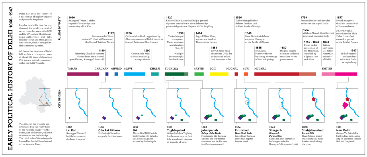
Throughout history Delhi has been the capital of various empires dating back to 6th century BC capital of Indraprastha to the old city of Shahajahanabad- the Mughal Capital; to being the colonial British Capital and then the political capital of newly independent India. The city has always been in a Capitalistic position and this has embedded the notion of ‘Power’ in its air. Battle after battle has been fought and the city has oscillated between times of peace and glory to extreme unrest. Each era has left its mark in the city’s built fabric, ruins of one capital added next to its ancestor’s. A new capital built on the foundation of the previous. Even post-independence the city has witnessed acts of violence and discrimination such as during the India-Pakistan partition, National Emergency of 1975 and 1984 Sikh riots.
Figure 1: Early political history of Delhi.
But behind the political tension lies a mystical side to the city, making Delhi famous as the Sufi Capital of India. The glory of Shahajahanabad is a favourite of poets; the old city having hosted Mirza Ghalib, the legendary Urdu poet for whom Delhi was the soul-of-the-world. The city itself was nominated for UNESCO World Heritage City for its Outstanding Universal Value based on its four precincts - Mehrauli, Nizamuddin, Shahjahanabad and New Delhi; the nomination was withdrawn but may be resubmitted. The city is already home to three UNESCO World Heritage Sites - Red Fort Complex, Qutab Minar, and Humayun’s Tomb. Along with these the city’s fabric is in a way held together by many protected and unprotected heritage monuments interspersed with the urban areas developed post independent. Even today the city with its many layers of history continues to fascinate authors and poets. William Dalrymple wrote about Delhi being a city with ‘a bottomless seam of stories’ in his book City of Djinns.
Administrative set-up Being a capital city and a Union Territory, Delhi is jointly administered by the federal Government of India (GoI) and the State Government of Delhi. As a result its growth and development is not just shaped by the Master Plans prepared by DDA but by various authorities working mostly independently of each other. Of these the following are under GOI: the National Institute of Urban Affairs (NIUA), the National Capital Regional Planning Board (NCRPB), the Delhi Urban Arts Commission (DUAC), and the Delhi Metro Rail Corporation (DMRC). Besides these the Public Works Department (PWD), Dialogue and Development Commission of Delhi, Delhi Urban Shelter Improvement Board (DUSIB) are amongst the Delhi government authorities. The urban management of the city and proper implementation of the master plans and building bye-laws is the responsibility of four Municipal Corporations - New Delhi Municipal Council (NDMC), North Delhi Municipal Corporation (MCD-N), East Delhi Municipal Corporation (EDMC), and South Delhi Municipal Corporation (SDMC) and the Delhi Cantonment Board. It is interesting to note that this multiplicity of organisation and their working in almost isolation w.r.t. each other though appalling is actually representative of the city itself.
Delhi’s growth is shaped by various National, State and City level policies and plans. The Master Plan of Delhi however, continues to be the most important planning document for the city specifying overall vision, land use distribution, infrastructure provision as well as development controls and building by-laws.
City of Mini Cities
Besides the various layers added over time, today’s Delhi when looked at through the urban lens comprises various typologies of settlements each having a very unique character, role and issues. The Master Plan categorises them as Special Areas of Walled City of Shahajahanabad and its extensions and Karol Bagh; Lutyens Bungalow Zone, Urbanised Villages and their extensions; planned plotted developments; low density government housing (under GoI); sub-cities of Dwarka,
Rohini and Narela (first proposed in MPD-2001); and unplanned areas including slums, JJ clusters, resettlement colonies, and unauthorised colonies. Overall the MPD-2021 defines Delhi’s density at 250pph but within these different typologies we see huge variations in density.
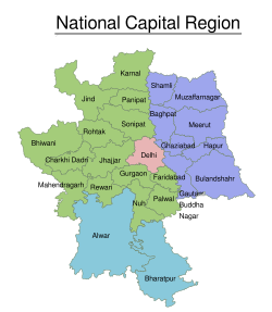
While Delhi has these many smaller cities within it, it itself is also part of the National Capital Region (NCR) which was defined with the concurrence of the participating States of Haryana, Rajasthan and Uttar Pradesh in 1985 under the National Capital Region Planning Board Act by the Government of India, to provide for the projected phenomenal increase in population (National Capital Region Planning Board, 2017).
Figure 2: Delhi's National Capital Region.
The Regional Plan-2021 prepared under this act provides for "a model for sustainable development of urban and rural settlements to improve quality of life as well as a rational regional land use pattern to protect and preserve good agricultural land, environmentally sensitive areas and utilise unproductive land for urban areas through an inter-related policy framework relating to settlement systems, economic activities, transportation, telecommunication, regional land use, infrastructural facilities such as power and water, social infrastructure, environment, disaster management, heritage and tourism."
Health impacts of the growing population of Delhi
As per the decadal data of the Census of India, the population of Delhi has increased from 40.66 lakh (over 4 million) in 1971 to 138.5 lakh in 2001 (nearly 14 million). The in-migration during same period has increased from 8.76 lakh (800,760) in 1971 to 22.22 lakh (over 2 million) in 2001. The share of out-migration from Delhi has slightly increased from 2.42 lakh in 1961-71 to 4.58 lakh in 1991-2001. The net migrants (in-migrants – out-migrants) have steadily increased from 6.34 lakh during 1961-71 to 17.64 lakh during 1991-2001. (National Capital Regional Planning Board, 2001). In 2016 the population of Delhi grew by nearly 1,000 a day, of which over 300 were migrants who came to the city to settle down. The share of migrants in the capital’s population growth thus reached 33% in 2016 — highest in 15 years (Times of India, 2018). Delhi therefore, also got the tag of the ‘Migrant Capital’ of India owing to the large number of service sector jobs it offers along with the highest per capita income among states. A senior Urbanist states: "Delhi concentrates much more on wealth, resources, infrastructure and quality of urban services than other metros. The national capital offers a relatively higher education and health system. ”
However, despite its ‘planning’ for the burgeoning population and infrastructure to cater to them, the city is crumbling under the pressure of its rapid urbanisation. The sheer population number along with the nature of development has had many impacts on the city’s health. It is widely understood that rapid and unplanned urban growth is often associated with a range of urban health hazards and associated health risks: substandard housing, crowding, air pollution, insufficient or contaminated drinking water, inadequate sanitation and solid waste disposal services, vector-borne diseases, industrial waste, increased motor vehicle traffic, stress associated with poverty and unemployment, among others (Indian Journal of Psychiatry, 2008). Each of these continues to be an issue in Delhi today.
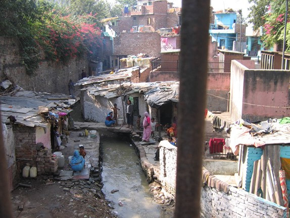
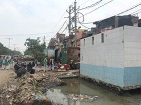
To begin with in terms of accommodating the in-migrants, the city faces a huge shortfall of housing stock. As per the note filed by the city’s civic bodies in 2012, 49% of the the total population of Delhi lives in slum areas, “unauthorized colonies" and about 860 jhuggi-jhonpri clusters with 4,20,000 jhuggies without any civic amenities (Times of India, 2012b). Most of these areas do not have electricity and water supply or sewerage, carry the maximum burden of diseases as well as social tensions, and their residents face fear of eviction. The MPD-2021 which projected Delhi’s population to reach 230 lakhs (23 million people) by 2021 aims at providing an additional of some 240 lakh dwelling units to house the existing slum population as well as the in-migrants through various strategies. The MPD further estimates that 50-55% of this housing requirement would be for urban poor in the form of houses of two rooms or less. However, little has been done to meet these targets. In 1962, Delhi had only 110 unauthorised colonies, built-in contravention of zoning regulations, where some two lakh people lived. This number rose to 1200 by 2017.
Figure 3: Slums of Delhi. Photos: Author
This rapid pace of Delhi’s urbanisation has had a huge impact on the city’s physical and social environment and consequently the mental health of its inhabitants. It has been well established that some children and adolescents in socioeconomically deprived urban areas may be drawn to antisocial behaviour. Although not exclusively an urban phenomenon, it thrives in inner cities where degradation, poverty, drug use, and unemployment result in an explosive blend favouring violent solutions (Lund and Cois, 2018). With half of the city’s population living in unplanned areas, it is no surprise that Delhi sees high rates of crime.
The range of disorders and deviancies associated with urbanisation is enormous and includes psychoses, depression, sociopathy, substance abuse, alcoholism, crime, delinquency, vandalism, family disintegration, and alienation (Trivedi et al, 2008). Chronic difficulties such as poor, overcrowded physical environments, high levels of violence and accidents, insecure tenure, and poor housing have all been shown to be associated with depression. Depression has strongly been associated with poverty and deprivation in low-and-middle-income countries (LMIC) based on both social causation theory and social drift theory (Lund and Cois, 2018). The social causation hypothesis proposes that the adverse social and economic conditions of poverty (such as financial stress increased exposure to income insecurity and reduced resources to protect individuals from the consequences of adverse life events) increase risk for mental illness. Conversely, the social selection/drift hypothesis proposes that people living with mental illness drift into poverty during the course of their lives due to disability, reduced economic productivity, increased stigma and increased health expenditure caused by their illness. The transition from rural culture to urban culture is one of the major stressors (Srivastava, 2009). The in-migrants need to acculturate and adapt not only to a new challenging urban environment, but also to alternative systems of symbols, meanings, and traditions (Trivedi et al, 2008).
The migrants to Delhi have had to deal with a diverse range of stresses caused by both the lack of infrastructure provision and also the meanings and power notions associated with these facilities. One of the meanings and symbolism that is apparent in Delhi’s urban fabric is that of Power. As mentioned earlier, historically Delhi has been the political capital of many empires. The pre-British cities discussed power and grandeur while responding to the ecological setting and ensuring a connect with nature for all. The natural elements - sun, wind, earth, sky, moon; all played a important role in design of public spaces. Take the case of Chandni Chowk- the main market street of Shahajahanabad connecting the Palace Red Fort to the Fatehpuri Masjid. The city fabric- the layout of streets and public places responded to the ecological setting, terrain, its location along River Yamuna and the trade link (the Silk Route). The settlements followed an organic growth pattern.
British influence on urban planning and design in Delhi
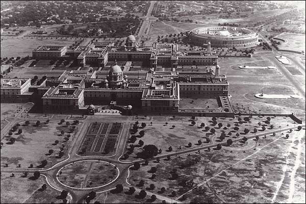
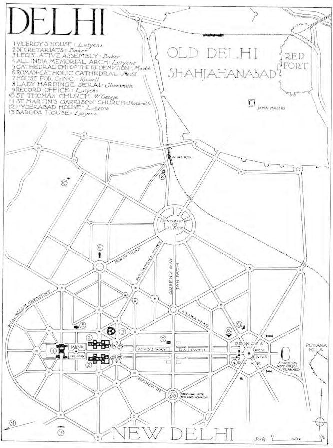
With New Delhi, the British capital designed by Sir Edwin Lutyens and Herbert Baker, the Garden City concepts were introduced. The use of geometry (a hexagonal grid) while laying out roads was also intended to impose their superiority and reinforce power and control of the British over the Indian sub-continent as a reaction to the Revolt of 1857. While there was an attempt to ensure continuity between the Central Ridge and River Yamuna by creating Central Vista (Rajpath) as a landscaped stretch, the avenues and roads were kept extremely wide to create a majestic feeling. The layout also incorporates generous green space, watercourses and the integration of trees and flowerbeds into the existing landscape in response to climate and dust. Visual connectivity was integral to the urban design scheme. Rajpath with the Rashtrapati Bhawan and the India Gate at its two ends has tremendous visual quality. Even the Parliament House and Connaught Place were visually linked to Jama Masjid. But in practice the imperial powers chose to look away from the locals and keep them restricted to their old areas away from the new capital.
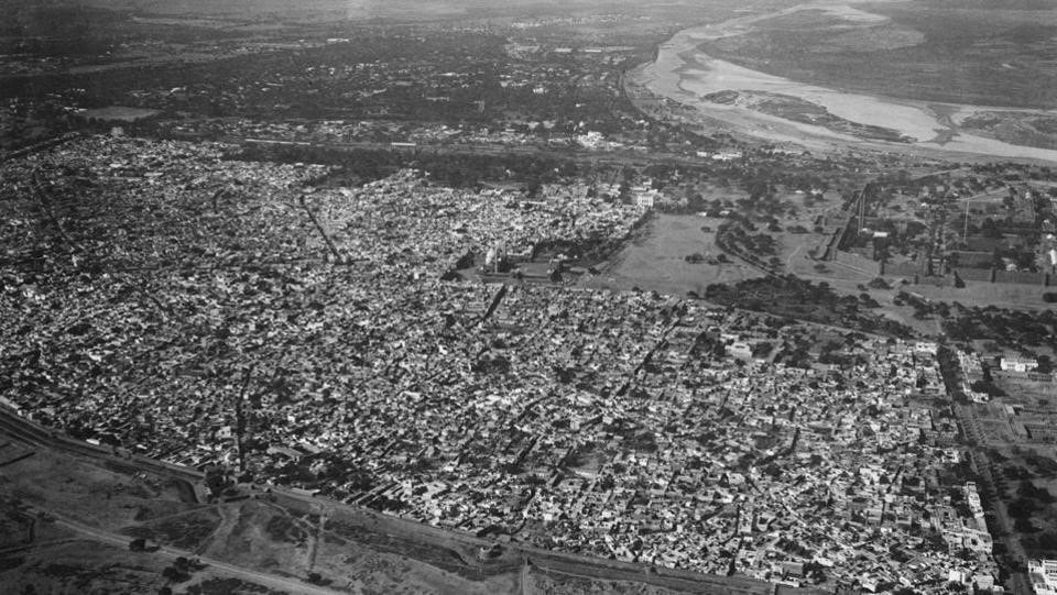
Figure 4a: Aerial View of Shahajahanabad looking east towards River Yamuna. 4b: Aerial view of New Delhi. Seen here are North & South Blocks along with the Parliament House in the background. 5c: Old Map of Delhi showing New Delhi and its location with the old city of Shahajahanabad.
'Along with the use of geometry to display power, the Britishers introduced a new building typology in the urban fabric - of ‘an object in space’ i.e. the street edge not being defined by the built mass but rather a boundary wall along the plot line. The building was located away from the plot edge and “setbacks” were left. Today, we continue to built using this typology and the boundary walls are getting higher and higher. This has not only broken the permeable relation between public and private domains but also resulted in the urban experience being defined by a blank wall. Anonymity and territorialisation enhanced by urban design. Thus the power play the Britishers introduced has continued to inform the planning and urban design of the city even today in many ways.
During the National Emergency between 1975-77, the city witnessed evictions, the most gruesome being the Turkman Gate Massacre when an estimated 7,00,000 people were displaced from slums and commercial properties over a period of 21 months, including large areas of the old city as part of a plan to ‘beautify’ Delhi (Homegrown, 2017). It is claimed that 400 people were killed to meet the political leaders' desire and whim to build a ‘Sanjay Minar’ (Minar is Hindi word for Tower) and for a shortcut or a wish to enjoy a clear view of India Gate from the Jama Masjid. This was not a new idea as Lutyens had in his original plan oriented the Rashtrapati Bhawan to look down the ceremonial avenue to the back of Jama Masjid (Liddle, 2018). The city oscillates between evictions and fantasies, all powered by urban design.
Residents in 'unauthorised colonies'
As mentioned earlier, today still almost half of the city’s population lives in slums and ‘unauthorised areas’ despite Delhi being the first city in the country to have a Master Plan and subsequent plans. This is indicative of not just faulty planning and implementation but also of an attitude of indifference to the incoming population. By referring to these in-migrants (who are forced to occupy vacant land in the absence of proper housing) as ‘unauthorised’ in itself involves power play. These people live with the fear of eviction regardless of the decades they have lived in that area and money invested in developing the neighbourhood level facilities and their own houses. Analyses suggest that at least 218 evictions have occurred between 1990 and 2007 in the capital, displacing 64,910 households of which only 52% have been re-settled (Bhan, Gautam and Shivanand, Swathi, 2013). These figures include the evictions carried out as part of preparation for the 2010 Commonwealth Games hosted by Delhi. While evictions are in themselves violent, the nature of evictions has changed with the poor getting peripheralised post-1990. Most resettlement sites pre-1990s were situated at the urban borders of the MPD-1962, while those post-1990s are situated at the edge of the urban plan boundaries of the MPD-2001. Some resettlement colonies created after 2000, remain outside even the urban boundaries of the latest MPD-2021. This marginalisation and hostility builds feeling of distrust and anger amongst those evicted adding to the city’s woes.
However, recently in November 2019, the government passed the National Capital Territory of Delhi (Recognition of Property Rights of Residents in Unauthorised Colonies) Bill-2019 aimed at granting ownership rights to over eight lakh (800,000) people living in 1,731 ‘illegal’ colonies. DDA has already delineated boundaries of 1,300 such colonies. While this is starting to get implemented, a senior Urbanist and Professor of Urban Design emphasises on the need for this to be followed up with very strong commitments towards improving the physical quality of the living environment. Else it would remain a good scheme on paper and be an extension of colonial mindset of keeping the weaker sections of the society at the margins.
Also, this colonial mindset is not just towards the in-migrants to the city. The Zonal Plans prepared under MPD-2021 for the sub-cities of Dwarka and Rohini do not take into account the existing urbanised villages. These sub-cities are being developed by urbanising the agricultural land on the periphery of the city. A standard pre-designed ‘sector’ layout has been repeatedly copy-pasted onto the available land based on the number of people that need to be accommodated. These sectors are designed to be ‘self-sufficient’ units catering to all the needs of the residents. This notion of a typical ‘self-sufficient sector’ though a misnomer in itself is also responsible for less social interactions and isolation in the city. With more and more people coming into the city, the feeling of anonymity is on the rise. As a senior Architect-Urbanist notes: “People are moving into Delhi very rapidly causing a social tension between the long-term residents and the short-term residents on account of distrust, fear and increased anonymity. This has led to social disconnect and isolation in the city.” The notions of “self-sufficiency” further breed the ideas of “An Anonymous Self” as separate from the larger “Cohesive Community”.
But while planning divides us, its failure as manifested in health issues unites us.
Health priorities in Delhi: Most Polluted City
The discussion on health in Delhi’s context currently focuses on affects of air pollution with Delhi being declared the most polluted city in the world by WHO reports. The Air Quality continues to be very poor with high concentrations of PM10 and PM2.5. Delhi has a PM2.5 rating of 153 micrograms, which represents an “unhealthy air quality” that causes “increased respiratory effects in general population” (Times of India, 2014). Besides the loss in productivity and added health expenditure, higher level of air pollution are found to be associated with lower levels of happiness (The Economic Times, 2019). According to the study published in the journal Nature Human Behaviour for the city of Beijing, the issues and findings cited resonate with the situation in Delhi. Zheng says, “Pollution also has an emotional cost. People are unhappy, and that means they may make irrational decisions. On polluted days, people have been shown to be more likely to engage in impulsive and risky behaviour that they may later regret, possibly as a result of short-term depression and anxiety.” Of note, Delhites have a reputation within India for being aggressive.
The city experiencing rapid urbanisation has a large amount of construction activity ongoing including that of construction of new metro corridors. All these activities add dust, soot, cement, wood dust etc to the atmosphere. In addition to this, factories in and on the outskirts of Delhi release toxic chemicals that contaminate the air. A study by Jawaharlal Nehru University (JNU) in 2013 showed that industries and thermal power plants contribute to 29 percent of the total air pollution in Delhi (Times of India, 2014). Vehicular emissions contribute to 63% of the city’s air pollution. Introduction of CNG-fuelled vehicles at the beginning of the century had “cleaned the city’s air”, but statistics show that Delhi’s pollution has increased five times over the past eight years. Today, Delhi is a city of cars (or private vehicles). The city boasts of one of the largest road networks in India i.e. 2,103 km/100km.sq. In 2008, there were 5.5 million vehicles in Delhi, the largest number in any world city. Nearly 1,000 more are added on a daily basis (Sahai SN, 2009). Interestingly, only 25% of the city’s population owns these private vehicles (cars/two-wheelers). (How to Decongest Delhi).
Since the main source of air pollution is vehicular emissions, reducing these is the most urgent and important next step. In January 2019, the GoI launched the National Clean Air Programme (NCAP) that aims to reduce toxic particulate matter in 102 cities by 2024, taking 2017 as the base year. The NCAP is a mid-term, five-year action plan that includes collaborative, multi-scale and cross-sectoral coordination between relevant Central ministries, state governments and local bodies; and forming city-specific-action-plans (India Today, 2019). In December 2019, the Delhi government approved the Delhi Electric Vehicle Policy-2019 with the primary goal to improve Delhi’s air quality by bringing down emissions from the transport sector. This policy will seek to drive rapid adoption of Battery Electric Vehicles (BEVs) such that they contribute to 25% of all new vehicle registrations by 2024 (The Economic Times, 2019b). This policy focuses on bringing down emissions by shifting from a petrol/diesel/CNG as fuel to using solar energy. However, this does not aim to reduce the number of vehicles on the road causing congestion. To effectively solve transportation issues and solve the environmental issues one needs to study these in the context of Delhi’s urban planning and development over the years which has lead to this crisis.
Other aspects of transportation affecting mental health in Delhi
The MPD-1962 defined Delhi’s growth as a poly-nodal city with the major city level public institutions, universities and colleges, hospitals and work centres located along arterial ring roads connecting the entire city. Thus the Ring Road and Outer Ring Road were developed and a dedicated bus route operated on these. This was the ‘transit oriented development’ model of the 1960’s. With the formulation of NCR in 1985, more nodes of opportunity came up outside the boundary of Delhi. People started to commute long distances for education and employment. These long commutes have also resulted in people having less time to spend with family and for leisure; along with more air pollution, more vehicular congestion and traffic jams. This have led to the expansion of road infrastructure as well as public transportation network mainly the Delhi Metro. However the public transportation’s expansion has failed to keep pace with the development of NCR and the opportunities being offered. Even within the city, the public bus system has failed to connect efficiently and comfortably. Besides these people mostly walk, cycle and use para-transit facilities like autos, cycle-rickshaws, shared autos, e-rickshaws. As per the report on How to Decongest Delhi about 35% of the city walks, 27% uses buses and 7% uses autos/cycle-rickshaws.
The MPD-2021 envisages an Integrated Multi-Modal Transport System interlinking Metro Rail, Ring Rail, Bus Rapid Transit System (BRTS), Intermediate Passenger Transport (IPT) along with making roads friendly for pedestrians, differently-abled and cyclists. However, the city has continued to cater more to users of private vehicles. In 2010, the Delhi government had undertaken a study “Transport Demand Forecast Study and Development of an Integrated Road Cum Multi-Modal Public Transport Network for NCT of Delhi” to cater to the public transport demand up to 2021. The study recommended building additional 149kms of metro rail, 40kms of light metro, 365.5kms of Bus Rapid Transit corridor (BRT) for inner city movement; and dedicated commuter rail service between Delhi and neighbouring NCR towns. Even then the projected modal share of public transport system just reached 50%.
Buses
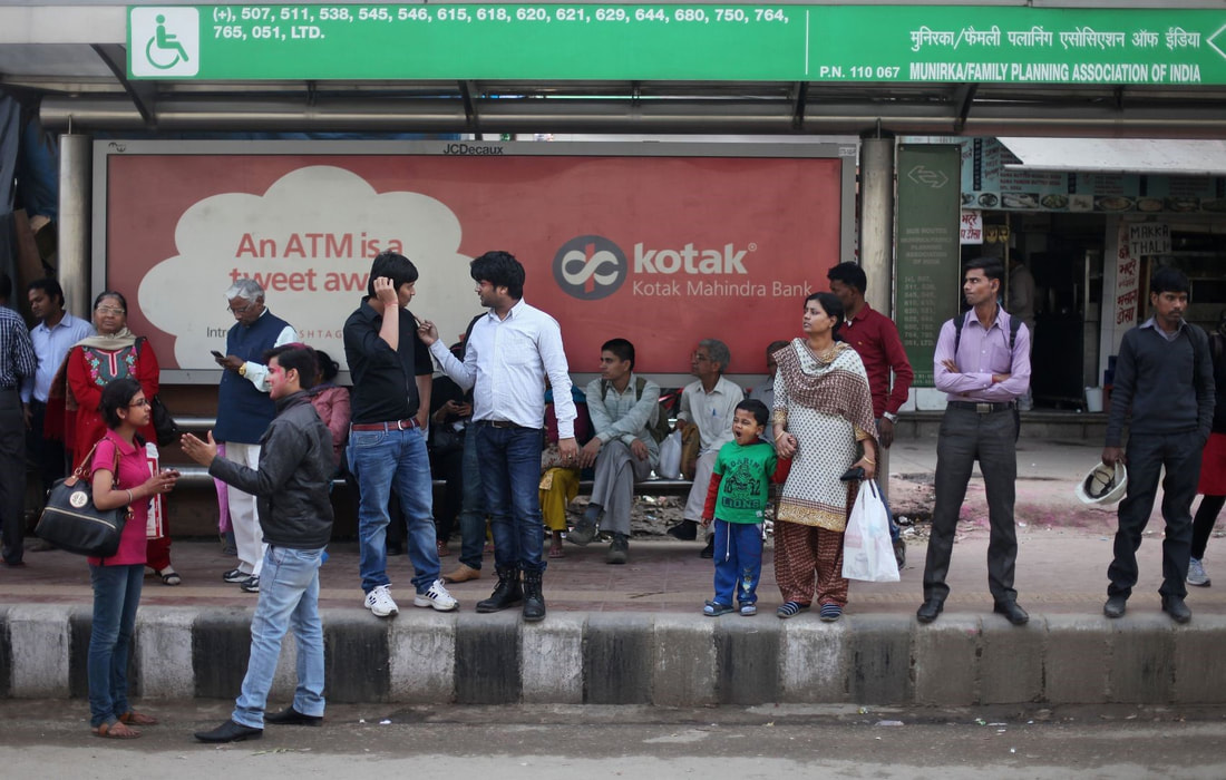
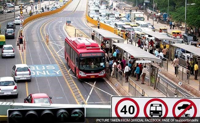
Public transport continues to be less-preferred for two main reasons: a) lack of comfort and b) lack of safety. The poor and irregular frequency, long waiting time, uncomfortable waits often without shade, makes it uncomfortable especially for elderly people, women, expecting mothers and adults with kids. Surveys have revealed that the travel patterns of women are different from men. Women make numerous trips of short distances therefore relying more on buses and para-transit facilities. But the city faces a huge shortfall in the number of buses on road: only 5,554 buses (against the required number of 11,000 vehicles) (Devdiscourse, 2018). Currently there are 1,275 low floor AC buses, 2,506 low floor non-AC buses and 101 Green standard floor non-AC buses and 1,672 orange colour standard low floor buses operating in the city. These were introduced at the time of constructing a Bus Rapid Transit (BRT) corridor in the city with the intention of developing a city-wide network of such corridors. In 2008, the first (& only in the city) BRT corridor became operational along a north-south arterial road. But sadly due to design flaws, implementation issues and political reasons the corridor was scraped off in 2016. Besides these the city hasn’t seen any major initiative towards increasing its modal share of buses. New bus stops were built in some parts of the city to be disabled-friendly, have signages for information on bus routes, be will-lit at night, and have better seating. Sadly these bus stops too failed as they were built either with a high kerb height, or obstructing the footpath or without any tactile paving for the visually impaired. In March 2019 the Delhi government approved the procurement of 1,000 electric buses as a push to combat air pollution. As per their guidelines, these buses would be equipped with with CCTV, Automatic Vehicle Tracking System (AVTS), panic buttons and panic alarms. Along with these the government is also planning to add more low-floor CNG buses to take the total number of buses plying in the city to 9,500 by May 2020.
However, while these new buses are being procured, the poor management of bus operation and the poor frequency of buses and therefore over-crowding, has resulted in making it a less preferred mode of travel.
Figure 5a: A typical bus stand with limited seating and located on high footpath. 5b: Delhi’s BRT Corridor before it was dismantled.
In fact, the lack of adherence to a schedule has lead to ‘waiting anxiety’ amongst passengers who remain uncertain about the time of bus arrival. One evidence of this ‘waiting anxiety’ is to see passengers spilling out on the road because their numbers have increased to unacceptable levels and they are anxious to board the bus faster than fellow travellers in order to bag a seat (Sahai, 2009). This also causes people to rush-and-push to board, adding to the aggression and hostility characteristic of Delhi’s public realm. Overcrowding is also one of the main facilitators of sexual harassment in buses.
Public transport in Delhi in general continues to be unsafe for women. Crimes have been committed on metro stations despite full CCTV coverage, in buses, on bus-stops, in autos and cabs; as well as while walking on the street in broad daylight. Which is why it came as no surprise that women-driven private vehicles were exempted during the odd-even scheme of the Delhi government in 2016 which was aimed at reducing vehicular pollution in the city. Sexual harassment is a ‘normalised’ part of a woman’s commute in Delhi. A survey conducted with female students revealed that over 89% had faced some form of harassment while traveling in the city, 63% of female students have experienced unwanted staring, 50% have received inappropriate comments, 40% have been touched, groped, or grabbed and 26% have been followed (Borker, 2018). Various research studies have shown that, an unsafe situation or crime encountered by a user would create great psychological fear resulting in reduced/no usage of public transport system at all. Fear of crime is thus widely recognised as a barrier to public transport use.
Underground and overground
It has been two decades since the foundation for the Delhi Metro was laid and the city’s air quality and sense of safety both have deteriorated. Today, the Delhi Metro is by far the largest and busiest metro in India, and is the world's 8th longest metro system and 16th largest by ridership running 389 kilometres serving 285 stations. The first Metro became operational in 2002 after being in planning from 1995.
While the metro was being planned during the same period, Delhi also built clover-leaf flyovers along its main arterial roads. The Okhla flyover was built along the Outer Ring Road and the AIIMS flyover along the Ring Road to “ease” traffic snarls. Thus began the city’s obsession with “non-stop high-speed” movement. While in 1982 (pre-NCRBA) the city had just five flyovers, it presently has 90 (of these 25 were built in the last decade) which is why Delhi is rightly also referred to as the ‘City of Flyovers’ (Phukan, 2014). Now almost every intersection along the Ring Road and the Outer Ring Road has a simple or clover-leaf flyover. Of course, over the course of time none of them have been able to balance the rise in vehicles. Traffic jams continue to plague the city. Also, it is observed that the point of congestion only shifts to the next intersection but largely people continue to be stuck in traffic. According to a report made by IBM’s global Commuter Pain study in 2013, New Delhi is among the top 10 cities in the world having the worst traffic jams (Phukan, 2015).
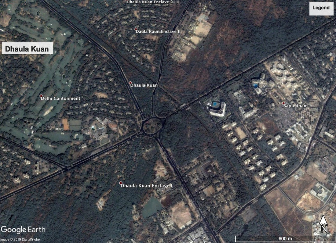
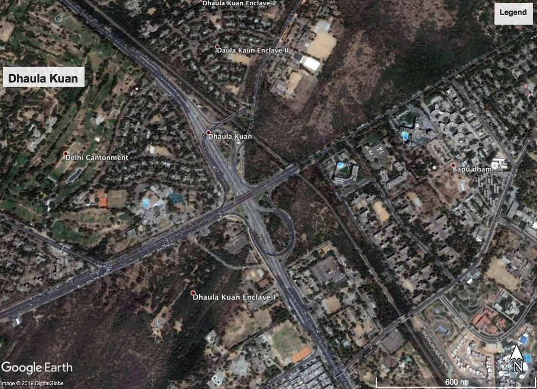
Figure 6: Google Earth images demonstrate the loss of tree cover associated with development of flyovers.
Also these flyovers have this ‘left-over’ space underneath them which has mostly been occupied by the homeless and destitute such as rickshaw pullers, ice-cream vendors, beggars and hawkers. At some locations, drug-addicts and vagabonds have made their homes while at other spots debris and garbage has been dumped (Hindustan Times, 2016). Experts suggest developing these as public places with diverse community activities. As these intersections have all become ‘signal-free’ they have added to the woes of pedestrians and cyclists needing to cross over. The story of clover-leaf flyovers is the most troublesome. Yet the city continues to build more and more flyovers with the latest plan to construct a double-decker flyover over one of the junctions. This proposal in itself proves that flyovers have failed in controlling traffic. And yet the city continues to plan more flyovers over existing ones.
The city fails to recognise that all that these flyovers have resulted in is a heightened lust for speed which in this author's assessment has matched the sex hunger of many. The city has seen many cases of abduction and rape along these flyovers as they facilitate one to grab-and-escape. The most serious is the Dhaula Kuan intersection where the number of crimes shot up after the flyover was built. Earlier this junction was a simple roundabout where traffic was forced to slow down. Then the extravagant clover-leaf flyover was built to ensure fast (read non-stop) vehicular movement.
It is no surprise that in the 2012 Delhi gang-rape case, the rape happened while the bus moved non-stop along the city’s main arterial roads. The case highlighted major safety issues with Delhi’s public transportation system like poor bus connectivity as well as lack of para-transit facilities especially in the off-peak hours of the day. With the city having an unsafe and unreliable public transportation system in place, a woman’s mobility and access to resources are limited preventing them from achieving their full potential. Indian women were found to be most stressed in the world according to 2011 Nielsen Report (add reference); men too are violent and aggressive.
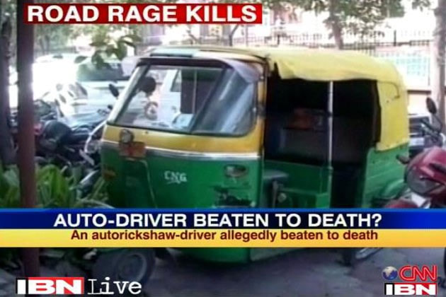
Delhi is also a city infamous for Road Rage. Statistically the city ranks fourth at the National level when it comes to most “fuming drivers” as per 2015 statistics released by the National Crime Records Bureau (Autocar India, 2016). Delhi senior police officials have stated that in 2013, 36 road rage incidents were reported and in 2014 till August, there were already more than 20 cases registered. The PCR receives almost 10-12 calls every day on minor scuffles on the roads of Delhi. Psychologists note that crowding causes aggression. But crowding itself cannot be blamed for road rage if we compare India and China. China despite having more vehicles and higher population than Indian cities, saw half the number of road deaths than India. According to psychologists, the aggressive-driving behaviour shown by many drivers is associated with “intermittent explosive disorder” in medical terminology which can be caused from getting annoyed over small issues to feeling superior than others to getting violent. Sociologists point to a breakdown in community values, and psychologists talk about the "intoxicating" feeling of power and anonymity offered by a modern automobile and in case of Delhi by the city itself.
Figure 7: News of Road Rage has become common in Delhi. Photo: from CNN.
Pedestrians and cyclists in Delhi
In Delhi everybody is in a hurry but confined to their cars stuck in a traffic jam. This is bound to be frustrating. But the situation is most frustrating for pedestrians and cyclists. An estimate by the Indian Road Congress (IRC) shows an average pedestrian in Delhi takes around seven to eight minutes to cross a busy intersection from end-to-end. (Hindustan Times, 2019).
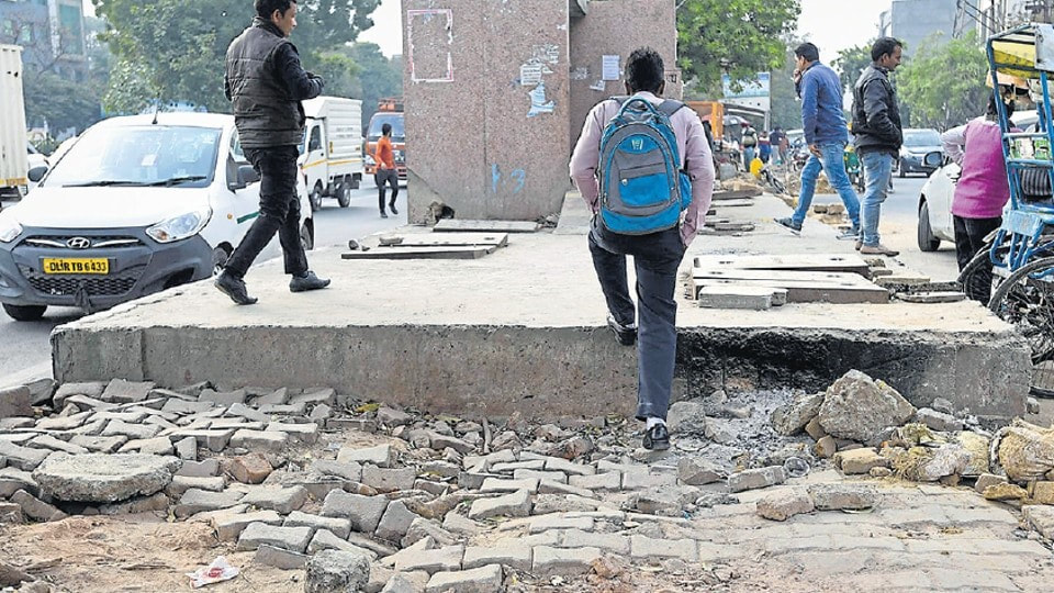
The struggle and battle for one’s right to the city is also visible on the road with every one fighting for space to walk, to cycle to drive, to park their vehicle or to just drive past and the car tends to win this battle. As mentioned earlier Delhi is a city of cars and these cars continue to dominate our road design ideology and thus our roads. With the coming of the Metro the discussion on safe and comfortable first/last mile connectivity has started. Multi-modal interchange zones are being proposed outside few metro stations. But the roads are mostly hostile towards pedestrians in many ways - lack of footpaths; too high footpaths going up to 19 inches from road level; broken paving, various obstructions, no tactile paving for visually impaired, no ramped ingress-egress; wide intersections, long waits to cross intersections; lack of shade, and lack of adequate illumination at night; to name the most commonly observed issues with footpaths in the city. Also, along mixed use commercial streets, the footpaths if provided tend to be encroached by shopkeepers, or vendors or are used for vehicular parking.
In September 2019, the Delhi government launched the Delhi Maintenance and Management of Parking Places Rules-2019 which prohibited vehicles being parked on footpaths. However, this is yet to be implemented successfully on the ground. Add to this the menace of public urination at some places and of badly designed and poorly located public toilets. There is a clear violation of the street design guidelines defined by both IRC and UTTIPEC. The notions of power play in the city also dominate the street design. The ‘fastest’ and ‘biggest’ vehicle dominates the movement pattern by occupying the centre and the slow-slim pedestrian is literally left to struggle at the edge. Pedestrians and cyclists are thus at huge risk on Delhi’s road. As per Delhi Police’s estimates for 2018, of the 1,604 people killed in road accidents, around 40% were pedestrians. Pedestrians are pushed off onto the vehicular carriageway to fight for space. Most people have accepted the notion that pedestrians are an ‘inconvenience’ to the car’s non-stop fast movement. And its not just the pedestrian, but even the cyclist (who is more neglected than the pedestrian), the street hawkers, and even the auto rickshaws and cycle-rickshaws. In the absence of dedicated para-transit stops and hawking zones, they are forced to locate themselves either on the vehicular road or along the footpath, either way causing further inconvenience.
Figure 8: A wide, high and broken median along one of the arterial roads in the city.
The city continues to have a binary approach of building roads aimed at middle and higher-income groups and metro for everyone else who cannot afford a private vehicle. The difference in the street design in different parts of the city further highlights the ongoing battle for domination and claim to the city. The New Delhi area or Lutyens Delhi boasts beautiful tree-lined avenues with well paved footpaths on both sides of the road but having very few pedestrians since its the political and diplomatic enclave of the city. While the other parts of the city especially along major transit hubs lack basic pedestrian provision. A study conducted by the Delhi Traffic Police in 2016 revealed that road accidents in the New Delhi area was at least 40 per cent lower than the rest of the city. It also showed that pedestrian deaths in accidents in this area were almost 85 per cent lower (Hindustan Times, 2019b).
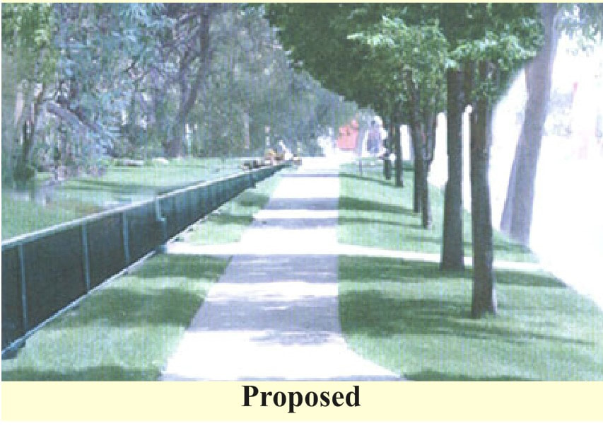
A senior Urban Designer offers a simple solution. He says, “Everybody likes a tree. Greenery along sideways and footpaths not just provides shade and increases your convenience while walking, it also soothes your senses and keeps you happy and calm. The moment you start walking with your senses feeling the surrounding, it slows you down and acts as a recreation for you. The hedges along edges of footpaths keep you from getting down on the roads, thereby bringing down the chances of accidents. Trees also provide shade to hawkers and autos, and can be used to create pause-points to slow down people and traffic.”
A senior Urban Designer offers a simple solution. He says, “Everybody likes a tree. Greenery along sideways and footpaths not just provides shade and increases your convenience while walking, it also soothes your senses and keeps you happy and calm. The moment you start walking with your senses feeling the surrounding, it slows you down and acts as a recreation for you. The hedges along edges of footpaths keep you from getting down on the roads, thereby bringing down the chances of accidents. Trees also provide shade to hawkers and autos, and can be used to create pause-points to slow down people and traffic.”
Case study: the Aapki Sadak project to improve local walking and cycling
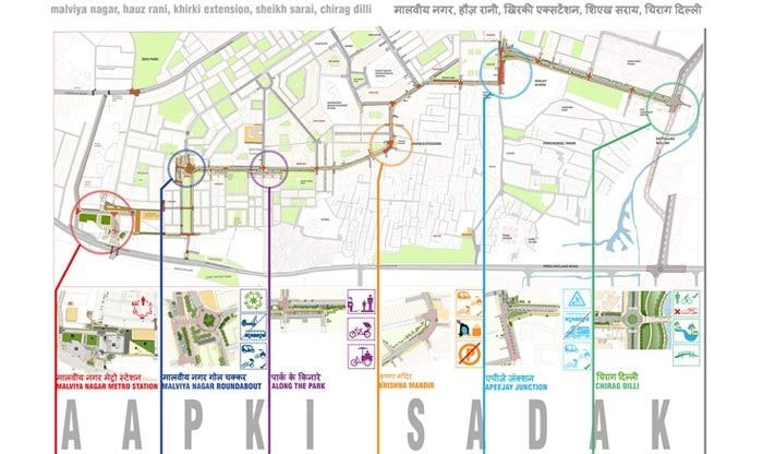
The Aapki Sadak project is a consultative project of urban design founded by architects, designers, artists and the local community. The project is based in South Delhi between the Malviya Nagar metro station and (earlier) BRT corridor comprising economically diverse localities. The project aims at improving neighbourhood level pedestrian and non-motorised transport accessibility to make the streets enjoyable and access to Metro and other public transport convenient. The technical team worked with the residents of different localities to develop a consensus plan for the improvement of their streets and environment friendly connections to public transport.[1] Ten community consultation workshops were held and a consensus reached.
During these consultations people from all age groups participated and shared their concerns. The elderly and children (and their parents) were stressed about not being able to walk comfortably to the neighbourhood park owing to the absence of footpaths coupled with high speed vehicular movement. The Project Director narrates, “A young college going girl had a concern that despite the metro station being within walking distance from her house, she was forced to take an auto or be dropped off via a longer route. This was because the direct street leading to the station had been gated and blocked to prevent movement of strangers through the neighbourhood.” This he says is becoming a major phenomenon throughout the city - territorial protection from strangers in the city. Delhi’s neighbourhoods are largely being gated to control pedestrians from taking short-cuts through them. He adds, “It was heartening to see youngsters wanting to walk instead of being driven around and were wanting freedom to play and cycle on the streets outside their houses.” The design proposal thus formulated and approved by the residents has been submitted to the Delhi government and awaits implementation on ground.
During these consultations people from all age groups participated and shared their concerns. The elderly and children (and their parents) were stressed about not being able to walk comfortably to the neighbourhood park owing to the absence of footpaths coupled with high speed vehicular movement. The Project Director narrates, “A young college going girl had a concern that despite the metro station being within walking distance from her house, she was forced to take an auto or be dropped off via a longer route. This was because the direct street leading to the station had been gated and blocked to prevent movement of strangers through the neighbourhood.” This he says is becoming a major phenomenon throughout the city - territorial protection from strangers in the city. Delhi’s neighbourhoods are largely being gated to control pedestrians from taking short-cuts through them. He adds, “It was heartening to see youngsters wanting to walk instead of being driven around and were wanting freedom to play and cycle on the streets outside their houses.” The design proposal thus formulated and approved by the residents has been submitted to the Delhi government and awaits implementation on ground.
Figure 9: Aap ki Sadak map, from: https://www.ashokblallarchitects.com/AAPKI-SADAK
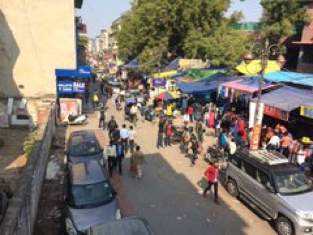
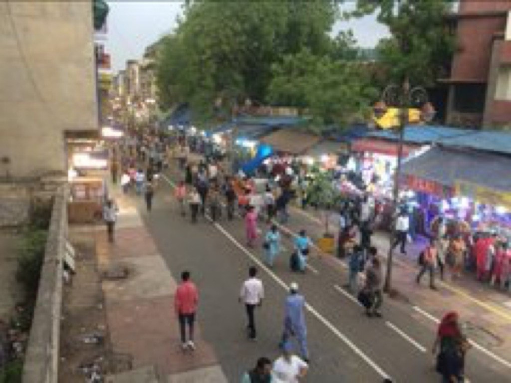
While the Aapki Sadak project was aimed at improving the neighbourhood experience, there have been attempts at pedestrianising major markets in the city. The Karol Bagh market - an old bustling market in the heart of the city, saw its main market street - Ajmal Khan Road pedestrianised in May 2019. The almost one-kilometre long stretch was decongested by providing off-street parking using old defund spaces; pavements lined with benches; the street decorated with flower pots; and space was demarcated for hawkers. This has led to reduced air pollution along the stretch as well as increased pedestrian footfall. The first phase of this project has been completed and now work will begin on the second phase. The North Delhi Municipal Corporation is now planning to implement the program along other market streets in the city as well.
Figure 10: The Karol Bagh Pedestrianisation project; before and after. Photo from the project's Twitter.
While these projects have a positive impact, their affect continues to be localised. Also, at times they are engaged in conflict with the environment. The Karol Bagh pedestrianisation involved uprooting 80 trees along that stretch alone. The city needs integrated holistic interventions implemented in the form of a proper city wide network. The DDA is now planning to undertake pedestrianisation of 22 locations in the city. Area-specific walk plans are intended to be prepared focusing on integration of walkability into various policies and projects, using technology for preparing walking tours, providing barrier-free pathways, pelican crossings near schools and major pedestrian crossings and earmarking multi-utility zones (MUZs) to accommodate street vendors and other public activities. The Delhi government has also partnered with NACTO and Savelife Foundation to redesign streets to make them safe and walkable. The team will start work on a 3km stretch witnessing high number of road fatalities and ultimately cover 1,300km road network in the city.The government is not just focussing on pedestrian safety but also reducing air pollution by carrying out plantation along 1,260kms of road length to arrest the roadside soil from becoming airborne. Delhi’s greens coming to the city’s rescue, which shouldn’t be a surprise considering that Delhi is one of the greenest cities in the country.
Green space
Both the MPD-2001 and MPD-2021, envisioned Delhi with a 15-20% of city’s area for Green/Recreational uses distributed in a hierarchical manner - Regional Park comprising the city’s Ridge, District Parks, City Parks, Community parks along with neighbourhood level parks. These are provided based on the planning norms specified to cater to a certain population. In addition to these, the city has various green spaces as part of the President’s estate, University Campuses, plantations along drains and roadside plantations. The Master Plans define the provision of the green spaces (i.e. adequacy) and based on these guidelines the Zonal Plans specify their exact location (i.e. accessibility). The neighbourhood level parks are usually within walking distance of most residences, most have an open gym and swings and thus see heavy footfall, especially in mornings and evenings.
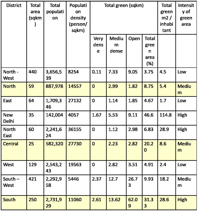
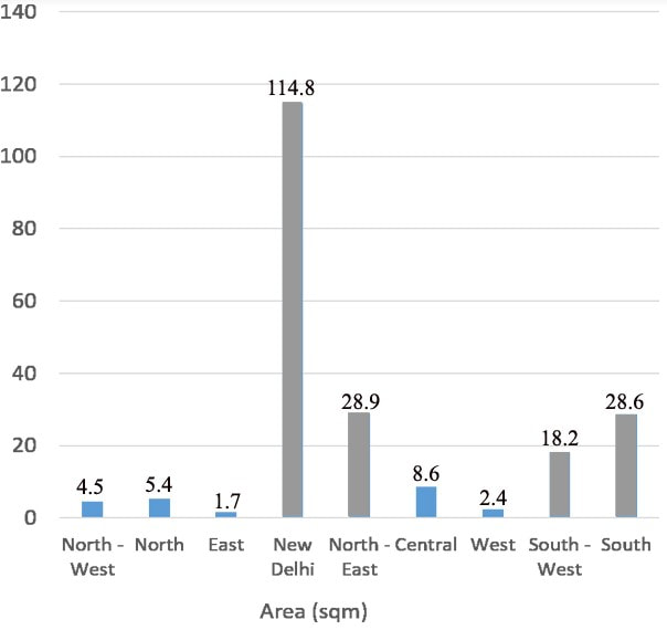
Figure 11: From: Khatri, Divya; Impact of Green Spaces on Quality of Life in Delhi; Master’s Thesis 2019.
The distribution of these greens in the larger setting has given the city a donut-shaped development unlike other megacities of the world. The central core of the city, comprising the Central Ridge and Lutyen's Delhi, serve as the lungs of the city. While adequate provision has been made in terms of area of green spaces, their distribution in the city indicates a discriminatory approach. A district wise analysis of the green spaces indicates that the New Delhi district having the lowest population density has the maximum green cover. Whereas, five districts out of nine, do not have sufficient green spaces. As per World Health Organisation (WHO) standards, a city should provide a minimum green cover of 9sqm. per inhabitant. If we see the green cover provision per inhabitant for different districts of Delhi, we see that there are great inequalities in provision; with the New Delhi district enjoying 114.8sqm. per inhabitant and five districts enjoying less than the minimum requirement. Another display of power in the capital.
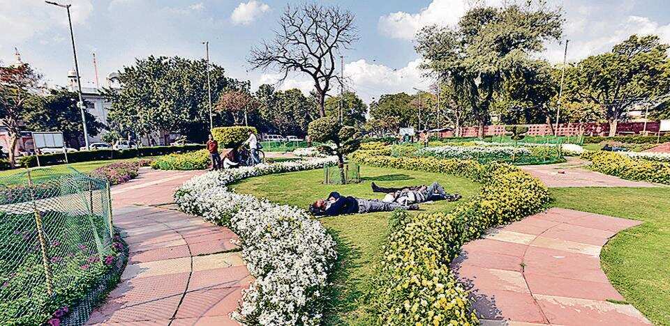
Furthermore, it is interesting to note that the New Delhi district got “Happiness Areas” in October 2018, developed by the NDMC under the national Smart Cities Mission. The NDMC directive states that “a green area is a safety valve, where people can find breathing space. Therefore, NDMC developed roundabouts, parks and gardens, public places in NDMC area as ‘places’ and planned around major public destinations, which act as civic pride, social connection and human happiness–all precious commodities in an increasingly congested urban landscape.” These large green spaces with ponds and flowers have been created with the intention of relieving the mental stress and physical fatigue of residents, as well as reducing air pollution. (Hindustan Times, 2019c). They can be found at Yashwant Place, Kautilya Marg and Nyay Marg junction, Ambedkar Vatika at Janpath, Bharat-ASEAN Maitri Park at Tughlak Road, Kautilya Park at Kautilya Marg, Entry Point at Minto Bridge and Jalebi Chowk in front of North Block Avenue - have all been developed as ‘happiness areas’ in the city.
Furthermore, it is interesting to note that the New Delhi district got “Happiness Areas” in October 2018, developed by the NDMC under the national Smart Cities Mission. The NDMC directive states that “a green area is a safety valve, where people can find breathing space. Therefore, NDMC developed roundabouts, parks and gardens, public places in NDMC area as ‘places’ and planned around major public destinations, which act as civic pride, social connection and human happiness–all precious commodities in an increasingly congested urban landscape.” These large green spaces with ponds and flowers have been created with the intention of relieving the mental stress and physical fatigue of residents, as well as reducing air pollution. (Hindustan Times, 2019c). They can be found at Yashwant Place, Kautilya Marg and Nyay Marg junction, Ambedkar Vatika at Janpath, Bharat-ASEAN Maitri Park at Tughlak Road, Kautilya Park at Kautilya Marg, Entry Point at Minto Bridge and Jalebi Chowk in front of North Block Avenue - have all been developed as ‘happiness areas’ in the city.
Figure 12: A view of the ‘happiness space’ at North Block (Sonu Mehta/HT Photo)
Research has established the role of green spaces in reducing crime. But these have been based at the neighbourhood level where the well-kept lawns and community plots encouraged more people to spend time outside in those spaces, leading to a greater degree of informal surveillance of the area and thus deterring crime (Spector, 2016). This may even work at the street scale where shaded-comfortable lively streets invite more people thereby making it feel safe. But at the larger district level parks, the huge scale of the various spaces and zones inside becomes important. The edge condition of the parks, surveillance, visual connectivity inside, nature of activity are all important design elements which need to be addressed.
However, these are not defined in the MPD’s or Zonal Plans and the city is yet to prepare Local Area Plans. Some of the city and district level parks are connected via metro but most are served by a bus route, others are reached by using private vehicles. These parks are huge in scale with a variety of spaces within them. Some of these spaces tend to be secluded making them the preferred spot for couples. At times these can become hotspots for crimes, especially sexual harassment and robbery. In 2003 a girl was gang raped in Buddha Jayanti Park- one of the most-visited city level parks, in broad daylight.
Another reason for crime in these parks could be that they have all been designed as ‘destinations’ in the city. This is a result of the colonial concept becoming a part of our urban design. Says a senior Urbanist, “Delhi’s green parks are all ‘go-to’ places and are not a part of one’s lived experience. They do not connect places such that one can take a short-cut through them to go from Point A to Point B, like we can do in Hyde Park, London.” This not only restricts the footfall in these parks but also limits ones engagement and connect with nature on a daily basis. As discussed earlier, Delhites are forced to commute long distances for work and education leaving little time for leisure. The way green spaces are currently provided in the urban fabric further reduces the possibility of an experiential engagement with the green areas.
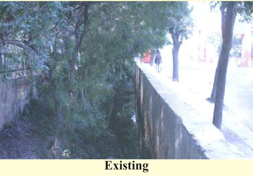
DUAC undertook an initiative in 2005 on Open Space Systems and Networks of Delhi aimed at developing a green network in the city as opposed to the (current) disjointed pockets of green. The initiative recognised that the older settlements of Delhi like Shahajahanabad had a recognisable open space network which responded to the terrain and the natural drainage channels were not built upon. But with urbanisation this principle of developing in harmony with nature was lost and the channels were constructed upon.
Figure 13: From DUAC’s proposal: Existing & Envisioned Greens of Delhi.
Encroachments have also come up along natural drainage channels and even the city’s River Yamuna. As per environmentalists, encroachments eat up to 40% of the river’s floodplains. To make matters worse, in a yet another major display of power and dominance, the Commonwealth Games Village (2010) encroached a huge chunk of Yamuna’s floodplains. The River Yamuna itself is filthy with the city discharging huge amounts of untreated waste into its water, going beyond its capacity. This has disrupted the entire hydrological flow pattern of the city. As per the ‘Composite Water Management Index’ (CWMI) report by Niti Ayog Delhi will run out of ground water by 2020. Combined with an increase in impervious surfaces (again due to urbanisation), the city now faces a mix of problems - lowering of water table, urban flooding during annual rainy season and with it the annual outbreak of dengue. Needless to say, the poor and the marginalised sections of the city are worst affected by this. The problem is not just within Delhi but also NCR. A satellite-based study around Delhi and NCR has indicated that its green forest cover was depleting in a rapid manner.
As per NCRPB, around 32,769 hectares of green areas and 1,464 hectares of water bodies was lost between 1999 and 2012. According to a Times of India report, in Delhi, water bodies have shrunken by 22.6 per cent, wasteland by 11 per cent and forests by 15 per cent. Delhi government has proposed the revival of 201 water bodies in the city hoping to turn Delhi into the City of Lakes. This is being planned after the successful revival of Rajokri Lake where recreational spots and play areas have been incorporated to ensure people’s participation in its maintenance. The proposal is based on using treated water to augment Delhi’s water supply and a large-scale revival of lakes to restore the city’s ecological balance and groundwater. The government is also working on creating six artificial lakes in the city using treated water.
Creating an interlinked network of water bodies and green spaces throughout the city (and even NCR) would help address the water issues, air pollution as well as facilitated an engaging connect with the greens and nature while providing alternate routes for movement to pedestrians and cyclists. For now the city greens and water bodies continue to be destinations to be reached and enjoyed for exercise, leisure and social interactions for a limited period of time during the day.
But while the greens have come to our rescue, they too need to be rescued in the city. A GoI undertaking to redevelop seven residential areas for accommodating its officials proposes to chop about 17,000 full grown mature trees. Of these around 1,000 have already been axed. This is happening while the city is facing severe levels of air pollution. The forest department has given clearance to cut trees spread across Sarojini Nagar, Nauroji Nagar, Netaji Nagar, Thyagraj Nagar, Mohammadpur, Kasturba Nagar and Sriniwaspuri.
While the Delhi High Court has put a stay on further felling of trees, there are reports of illegal chopping ongoing. Besides adding to the pollution, these projects aim at re-densifying these areas increasing the burden on infrastructure at a time when the city faces acute water shortage and traffic congestion. The parking of cars requires multiple basements as well as surface parking. This is affecting tree cover throughout NCR. These projects were approved after the disastrous redevelopment of East Kidwai Nagar which should have served as a wake-up call for the city. It is important to note that the choice of the colonies to be redeveloped, located in the heart of the city along the main arterial roads, is based on greed for power and domination. The detailed proposals while claiming to be for government officials have a significant proportion of commercial space and private residences. Even the staff quarters are mostly for senior officials and the junior level staff is largely excluded. A project like this can have no space for trees for while power is violent and disrespectful, a tree is kind and humbling.
One may also argue that if Delhi is the greenest city in the country and if greenery has a calming effect then how is it that Delhi also experiences high levels of aggression and road rage? A senior Urban Planner raises the same point. As per the India State of Forest Report 2013, the forest cover (as per the respective city’s Master Plan) of Mumbai is 86.57 sq. km and of Delhi is 180 sq. kms. However, as per the 2015 statistics released by National Crime Records Bureau, Delhi reported 7,411 road rage incidences whereas Mumbai reported 3,963 cases only. The road side greens certainly seem to have a relaxing and a comforting effect on people moving along them. But considering the city’s obsession with speed, many people are just rushing past and not benefiting from being in the greenest city.
Pro-social space
Besides the hierarchy of green spaces, Delhi has a wide range of built and open places with varying degrees of publicness for social interactions and activities. Most of the green spaces like parks, India Gate lawns, Lodhi Garden, Central Park, Ramlila Maidan, Garden of Five Senes; are open to one-and-all. As are the city level markets - both street markets like Karol Bagh and Rajouri Garden; and cluster markets like Sarojini Nagar and Lajpat Nagar. Then there are places like Dilli Haat, Delhi Zoo, various Heritage Complexes like Qutab Minar, which are ticketed. Globalisation brought the Mall typology to the city - a privatised public space not open to all. This space being free from beggars and offering an air-conditioned controlled environment, has made itself a popular destination.
Besides open markets and malls, the city has a five-tier system of commercial areas as defined by the MPD-2021. Metropolitan City Centre, District Centre, Community Centre, Local Shopping Centre and Convenience Shopping Centre - these have all been proposed to accommodate shopping, offices along with functions like cinema, hotel, restaurant and various community services. The MPD also provides for socio-cultural facilities like Banquet Halls, Multipurpose Community Halls, Recreational Club, fair grounds, religious facilities and sports complexes. These are all very introverted functions designed to cater to a certain footfall at a time. But these too have been designed as destinations and are not a part of one's lived experience. In the pre-colonial cities, market streets were the most active open spaces for people to come together. Along with these, the religious institutions too were designed as spaces for community gatherings. While churches and gurudwara are mostly introverted functions; temples and mosques have resulted in activating the streets. These too had a hierarchical system and were well-stitched in the urban fabric. However, this tie too has been snapped. In the new developments even the temples and mosques are designed with their activity spaces limited to the inside of the complex. Their built form and design continues to make them important landmarks in the city’s urban fabric.
Besides open markets and malls, the city has a five-tier system of commercial areas as defined by the MPD-2021. Metropolitan City Centre, District Centre, Community Centre, Local Shopping Centre and Convenience Shopping Centre - these have all been proposed to accommodate shopping, offices along with functions like cinema, hotel, restaurant and various community services. The MPD also provides for socio-cultural facilities like Banquet Halls, Multipurpose Community Halls, Recreational Club, fair grounds, religious facilities and sports complexes. These are all very introverted functions designed to cater to a certain footfall at a time. But these too have been designed as destinations and are not a part of one's lived experience. In the pre-colonial cities, market streets were the most active open spaces for people to come together. Along with these, the religious institutions too were designed as spaces for community gatherings. While churches and gurudwara are mostly introverted functions; temples and mosques have resulted in activating the streets. These too had a hierarchical system and were well-stitched in the urban fabric. However, this tie too has been snapped. In the new developments even the temples and mosques are designed with their activity spaces limited to the inside of the complex. Their built form and design continues to make them important landmarks in the city’s urban fabric.
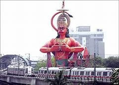
Figure 14: Hanuman Mandir at Jhandewalan junction is a famous landmark in the city.
Today, it is the parks and the mixed-use market streets of the city that are the most preferred public places. The city also has many heritage monuments (other than the World Heritage Sites) interspersed in the city’s fabric which provide opportunities for people to come together. Purana Qila and Humayun’s Tomb complex have also hosted concerts and performances. Nehru Park in Lutyens Delhi is another favourite for its Jazz and Food festival. Lodhi Gardens sees different types of activities throughout the day from people coming early in the morning for exercise and yoga, to tourists visiting the tombs, to couples cuddling in the rose bushes, to children playing in the greens.
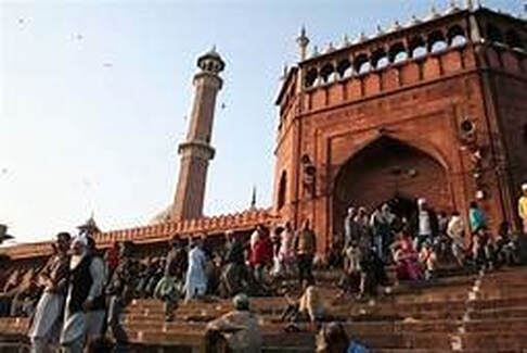
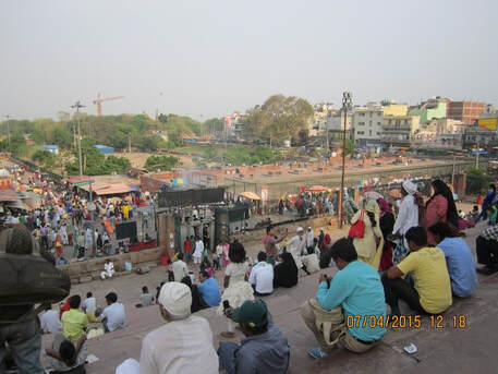
Figure 15: Left: View of the main entry steps of Delhi’s Jama Masjid. Right: The steps of Jama Masjid looking towards Meena Bazaar.
Landmarks and heritage
However, by and large the city has neglected its heritage. In the fast pace of today’s city life, connection with history is loosely felt. The demands of today and preparations for tomorrow have made yesterday’s glory secondary. This is best illustrated in the proposal prepared to redevelop Chandni Chowk - the market street of Shahajahanabad connecting the Red Fort with the Fatehpuri Masjid.
Chandni Chowk (also called Moonlight Square) was designed by Shah Jahan’s daughter Jahanara Begum to connect the Red Fort (seat of power) with the Fatehpuri Masjid in the 17th Century AD. A canal Nahr-i-Bihist (Canal of Paradise) ran through the centre of the street. There was an octagonal pool and the reflection of the Moon in this is believed to have given the street its name. The street had shops and resting quarters for traders and merchants. There was a strong visual connect between the market and the Red Fort. After the Revolt of 1857, Britishers filled up the canal and introduced the Tram in its place. They also added a Clock Tower, Town Hall and Flora Fountain as elements of power and domination. Today, the market street is extremely crowded and congested. The built density has grown and old structures are crumbling. As a solution, the proposal aims to pedestrianise the street with wide footpaths on both sides and allowing only for the movement of non-motorised vehicles. However, the proposal instead of reviving the canal or re-establishing the visual connection; has located all utility ducts, transformers, substations, police booths, and even toilet blocks along the central verge. As a result the work on this street has been put on hold after protests from architects and historians. Work on site started in December 2018 and the project is planned to be completed by March 2020. This is a perfect example of how we have become disconnected with nature and become 'practical' in our approach.
While Chandni Chowk is centuries old and is recognised as a part of the city’s heritage by definition, the Hall of Nations and Industries, built post-independence didn’t make this qualification and in an “act of outrage” was demolished in 2017. The Hall of Nations, the world’s first and largest-span space-frame structure built using cast in-situ reinforced concrete used a tessellating triangular structure to form a capped pyramid, holds special significance in India’s post-colonial history. It was inaugurated in 1972 to commemorate twenty-five years of the young country’s independence. The building was a part of the Pragati Maidan complex hosting trade fairs and exhibitions. Attempts were made to save it by national and international organisations. But for displaying of one’s power and supremacy over previous governments, the structure was demolished and demolished in a clandestine manner at night. The city woke to the shock of losing its modern heritage.
Citizen participation in urban development
Luckily while power dominates, democracy does find some ways to make its presence felt. The city has various spaces for public protests and political agitations - Ram Lila Maidan, Jantar Mantar Road, and Rajpath. These have over the decades hosted various protests for citizenship rights, for women’s safety, against communal violence, against failure of law and order. However, now even Rajpath: the Kingsway is under attack. The GoI has launched an ambitious project to redevelop the Central Vista (Rajpath and the offices along it). The Central Vista which was designed to display the imperial power shall now be re-designed to portray ‘New India’. This would be done at the cost of consuming a major part of the existing green open public space while adding construction waste and debris to the already choking city. The lawns of Rajpath are a very popular space for recreation for it is completely inclusive - it caters to all sections of the society. This publicness of the area would be taken away. Post-independence, Rajpath transformed from being a symbol of power to the seat of democracy. However, the entire process in which the Redevelopment has been proposed and approved by the government, the people are left out entirely. Urban designers across the country say that the government should have consulted the public before taking a decision. A senior Professor from the School of Planning and Architecture said, “For any project of this scale, magnitude and significance in a location as critical as this area... the heart of our national capital, there needs to be a widespread consultation before any decision to change is taken.” He added, “It is most important to formulate a comprehensive urban design, landscape and conservation strategy for this precinct and all other areas of historical significance within which such projects can be considered or imagined.”However, so far despite opposition from experts and PIL’s, the government is moving ahead with the project even in the midst of the Covid-19 lockdown.
While the smaller public spaces shall continue to exist, the blatant display of power and arrogance over the city’s heritage is bound to percolate to them as well. This can already be witnessed in the street design and the colonial definitions of open/green/social spaces that the city continues to choose.
SWOT Analysis
STRENGTHS
|
WEAKNESSES
|
OPPORTUNITIES
|
THREATS
|
Conclusion
Lessons from Delhi that could be applied to promote wellbeing and good mental health through urban planning and design in other cities
1. Guiding the nature of urbanisation. In Delhi, while NCRPB tried to deflect the in-migration to its satellite towns, it failed owing to the way industries and economic centres were planned. Planning needs to integrate all aspects of the city.
2. Interdisciplinary approach led by urban design(ers). The need for interdisciplinary research to measure the impact of urbanisation on mental health. This would automatically pave the way for multidisciplinary teams working on the Master Plan/Zonal Plan or the development plan for any city. In the Indian context, the discipline of Urban Design has huge potential of being the integrator of all urban systems.
3. Citizen engagement is key to ensuring well-being especially when there is indifference from the government.
4. Integrated Development. It is imperative for any development to be people-centric and sustainable, that it be planned holistically with all urban systems integrated together.
5. Network of Public Spaces. Equitable distribution of green spaces (and other resources) to all parts of the city. It doesn’t suffice to provide green spaces in terms of area defined in square kilometre per capita at the city scale. Safe and convenient access to these spaces also needs to be ensured. These green spaces also need to be connected with other public places as well as transportation nodes.
6. Flyovers do not solve traffic problems. Our urban design needs to shift focus from traffic to transportation. Flyovers are a reaction to traffic and yet they fail to solve the problem. Cities need to be committed to providing safe and comfortable public transportation facilities to each inhabitant.
7. Connection with one's past. A city needs to very carefully choose which aspect of history and heritage it intends to stay connected to and build tomorrow’s foundation on: power and hostility or humility and health.
Recommendations for Delhi to improve public mental health and wellbeing through urban planning and design
1. Urgent development of affordable housing: This would have to be done by first identifying pockets within the city served by an efficient public transportation system. Focus should be on providing affordable housing and basic amenities to one and all (For example, the proposal to re-develop seven colonies for government housing is widely considered to be unhelpful.)
2. Increase integration of nature into daily life in the city: The natural hydrological flow of water should be restored and a blue-green network be created interlinking the entire city through an hierarchy of green open spaces.
3. Expand the public transport system: This should include not just the Delhi Metro but also utilising the Ring Railway. The fleet of buses has to increase along with better para-transit facilities.
4. Improve walkability and bikeability: The city needs to be pedestrian friendly in order to take advantage of an improved public transport system. There is huge potential to also develop a cycling network in the city.
5. Improve safety: For this one has to re-design the streets to have natural surveillance, slow down traffic, and provide various activity spaces. A public place network needs to be developed across the city which needs to be integrated with the blue-green network and public transportation facilities.
To define recommendations for a city like Delhi is easy. Implementing them is a challenge. The biggest learning would be how not to urbanise. The city which was formed as grand capitals is now a city of problems, problems which we have created by faulty planning and design. Delhi teaches us not to get intoxicated by power and to remain connected with nature and stay humble and calm. The children of the city are more aware of health issues and are pro-active in creating a better future. Together these recommendations hold the key to redeem the city’s sins.
About the Author
|
Kriti Agarwal is an architect-urban designer with over a decade of diversely rich professional experience. Her work is uniquely situated at the intersection of social justice, public health and environmental sustainability. She completed her Bachelors in Architecture from the TVB School of Habitat Studies, New Delhi followed by Masters in Urban Design from the School of Planning and Architecture, New Delhi. Having intimately engaged at the grassroots level for most part of her professional career, she can simultaneously operate at various scales interlinking the smallest construction detail to larger policies and theories. She deconstructs spaces into its constitutive sociopolitical elements such as human health, safety, criminality, discriminations and deformities; all of which are rarely examined in academia. Therefore, aiming to bridge the seemingly irreconcilable theory-praxis gap, Kriti decided to rejoin academia and is currently engaged as an Assistant Professor at the Jindal School of Art & Architecture, India.
|
References
Autocar India (2016). Road rage on the rise in India.
Bhan, Gautam and Shivanand, Swathi, Analysing Displacement in Delhi from 1990 to 2007: (Un)Settling the City. Economic and Political Weekly, 2013: 48(13).
Borker, G (2018). Perceived risk of street harassment and college choice of women in Delhi. VoxDev.
Delhi Development Authority (2012). Safety, Freedom and Respect for Women in Delhi.
Devdiscourse (2018). Delhi facing acute shortage of public transport; requires 11,000 buses: AAP govt to SC.
Hindustan Times (2019). Major intersections in Delhi death traps for pedestrians.
Hindustan Times (2019b). Green patches, seats at regular intervals increase walkability quotient.
Hindustan Times (2019c). Enjoy nature and relax at Delhi’s ‘happiness areas’.
Hindustan Times (2016). Flyovers in south Delhi wastes vital public space.
HuffPost (2016). World Mental Health Day: India's mental health crisis in numbers.
India Today (2019). Govt launches National Clean Air Programme to tackle air pollution: Key features.
Khatri, Divya (2019). Impact of Green Spaces on Quality of Life in Delhi; Master’s Thesis.
Liddle S (2018). Connaught Place and the Making of New Delhi, Speaking Tiger Publishing. Exerpt.
LiveMint (2017). Over 5 crore people suffer from depression in India: WHO.
Lund C, Cois A: Simultaneous social causation and social drift: Longitudinal analysis of depression and poverty in South Africa. Journal of affective disorders 2018, 229:396–402. pmid:29331699
National Capital Region Planning Board (2017). Evolution of concept of National Capital Region.
National Capital Regional Planning Board (2001). Migration study of Delhi and NCR.
Phukan, RS (2015). Traffic congestion in Delhi: causes, outcomes and solutions. My India.
Phukan, RS (2014). Flyovers in Delhi: aren't these a menace to people? My India.
Report of High Powered Committee on How To Decongest Delhi.
Sahai SN (2009). Bus system reform in Delhi. UITP Asia Pacific Assembly.
Spector, J (2016). Another Reason to Love Urban Green Space: It Fights Crime.
Srivastava, K. Urbanization and mental health. Ind Psychiatry J. 2009;18(2):75-76. doi:10.4103/0972-6748.64028
The Conversation (2016). Why ‘green cities’ need to become a deeply lived experience
The Economic Times (2019). How air pollution is making people unhappy.
The Economic Times (2019b) AAP govt unveils sops, targets 25% new EVs in Delhi by 2024.
The Hindu (2016). Delhi: a city on short fuse.
The Indian Express (2014). Delhi most polluted city in the world: WHO.
Times of India (2018). How Delhi became the migrant capital of India.
Times of India (2017). 7.5% Indians suffer from mental disorders: WHO report.
Times of India (2014). Five Reasons Why Delhi is the Most Polluted City in the World .
Times of India (2012). One in five Indians needs mental health counselling, reveals.
Times of India (2012b). 'Half of Delhi’s population lives in slums'
Trivedi JK, Sareen H, Dhyani M. Rapid urbanization - Its impact on mental health: A South Asian perspective. Indian J Psychiatry. 2008;50(3):161-165. doi:10.4103/0019-5545.43623
